Your Gateway to Spatial Solutions
Call/WhatsApp +92 345 2997342
We specialize in providing cutting-edge solutions for change detection allowing our clients the ability to detect and monitor changes on the Earth’s surface over time, providing valuable insights into a variety of industries, including agriculture, environmental monitoring, urban planning, and many more.

At Geoimage, we specialise in providing cutting-edge solutions for change detection allowing our clients the ability to detect and monitor changes on the Earth’s surface over time, providing valuable insights into a variety of industries, including agriculture, environmental monitoring, urban planning, and many more.
Archival and fresh capture available, making all necessary data readily available.
Capture frequencies, ranging from weekly, monthly, quarterly, annually, or even custom periods.


Positive and negative land change: Our change detection solutions include positive and negative land change detection. Positive land change detection identifies areas where there has been an increase in vegetation or land cover, such as reforestation or regrowth after a natural disaster. Negative land change detection identifies areas where there has been a decrease in vegetation or land cover, such as deforestation or urbanisation.
Spectral analysis: Our solutions use multiple spectral bands to capture various wavelengths of light. This enables us to analyse a wide range of phenomena, from vegetation health to mineral composition, and identify changes that may be indicative of specific conditions.
Compliance monitoring: Our solutions can be used for compliance monitoring, enabling organisations to ensure they comply with legal and regulatory requirements. We can monitor land use and land cover changes, deforestation, agricultural activities, and infrastructure development, providing objective data to verify compliance.
Machine learning and artificial intelligence: Our solutions utilise machine learning and artificial intelligence to analyse large volumes of satellite imagery data, making it possible to detect even subtle changes in the environment or infrastructure over time. By leveraging deep learning algorithms, we can identify patterns and trends in the data that may be difficult for human analysts to detect.
Historical archives: Our solutions access historical imagery archives which enable us to conduct change detection analysis by comparing current and past data. This comparative analysis can assist in identifying long-term trends and patterns that provide valuable insights into past and present conditions. By leveraging these insights, organisations can make informed decisions based on a comprehensive understanding of changes that have occurred.
Our comprehensive outputs offer change analysis and customisable visualisation
Change vectors can be generated in any industry GIS format.
Raster data can be streamed as Web Map Tile Service (WMTS).
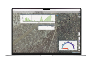
A customisable groundWATCH dashboard is available to display changes. The groundWATCH dashboard enables users to query changes based on spatial location and time of change.
Produce reports that details the amount of area that has undergone modifications within a specific region during a specified time period.
Disturbance monitoring: Monitor and assess the impact of disturbances, such as deforestation or land development, on ecosystems.
Gas leak detection and monitoring: Identify and monitor gas leaks in industrial settings for safety and environmental compliance.
Fire detection: Detect and track wildfires to support firefighting efforts and minimise their impact.
Marine vessel/harbour management and monitoring: Monitor vessel traffic and manage harbour activities for improved maritime safety and security.
Algae bloom detection and monitoring: Identify and track algal blooms to protect aquatic ecosystems and water quality.
ClassificationClassification groups image pixels into classes based on spectral and spatial traits. Valuable data, like land cover and features, are extracted from
Change DetectionWe specialize in providing cutting-edge solutions for change detection allowing our clients the ability to detect and monitor changes on the